
Stop searching the whole network. Know exactly where to send your leak crews first.
Fracta Leak Zones
Who It's For
Fracta Leak Zones is built for distribution system managers, water loss and non-revenue water (NRW) teams, operations superintendents, and the consulting engineers who support them. It is designed for utilities that survey miles of pipe with no clear starting point, or that only find leaks after a main breaks or a customer calls.
Survey budgets and crew hours are limited. Leak Zones tells you where to spend them first, so every field day covers the parts of the network most likely to be losing water.
What It Is
Fracta Leak Zones is an AI-driven service that ranks the areas of your distribution network most likely to contain leaks, and the pipes inside each area most worth investigating.
It starts with Fracta's Likelihood of Failure (LOF) model, which combines your pipe inventory and break history with environmental data Fracta supplies, such as soil, climate and topography. Adding a periodic SCADA export, our recommended path, turns that risk ranking into a leakage signal by showing where water is actually being lost.
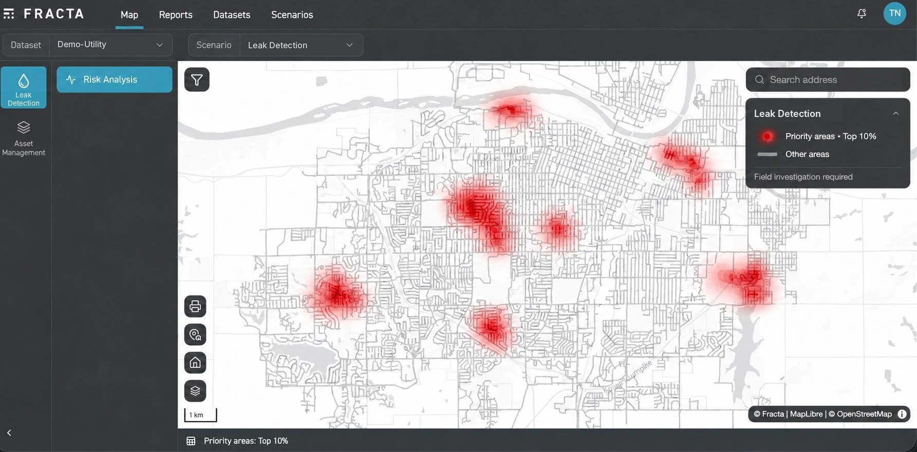
Results are delivered as a map of priority areas in the Fracta platform, refreshed 1 to 4 times a year. No new sensors. No hardware in the ground. No live SCADA connection.
Why Utilities Use It
Shrink the Search Area
Instead of sweeping the entire network, crews start in the priority areas flagged in each delivery. Survey hours go to the parts of the system most likely to be leaking, not to miles of healthy pipe.
Recover Water and Revenue Sooner
Finding leaks earlier cuts non-revenue water and the cost of treating and pumping water you never bill. It also lowers the chance that a slow leak turns into an emergency main break.
Start With the Data You Already Have
All you need to begin is a pipe inventory and break history. There are no sensors to install, no live system integration and no prior Fracta assessment required. Send what you have and we confirm the scope.
How It Works
1. Data Collection
Only two datasets are required: a GIS pipe inventory (pipe ID, install date, material and diameter) and break history (a date plus pipe ID or location for each break). For the sharpest targeting, we recommend adding a SCADA export of hourly flows, tank levels and pressures in CSV or Excel, plus GIS of pressure zones and facilities. Gaps are fine; we tell you up front how they affect scope. We only ask for a SCADA export once a quarter. No live connection.
2. Risk Modeling
Fracta's LOF model scores every pipe segment by combining your records with environmental data we supply, including soil, climate and topography.
3. Leak Zone Prioritization
We combine pipe risk with the leakage signal in your SCADA data to flag priority areas for field investigation (the top 10% of the network in each delivery) so crews know where to begin.
4. Field Confirmation and Refresh
Your crews confirm leaks on site, or Fracta can include on-site pinpointing through a leak detection partner as an optional add-on. Updated priority areas arrive 1, 2, 3 or 4 times a year, timed so your team can investigate and act on each set before the next one lands.
Leak Zones Outputs
Priority Areas Map
Every delivery lands in the Fracta platform as a map of priority areas for leak investigation, so crews know where to start before they roll a truck.
Example Fracta Leak Zones output: priority areas (top 10%) flagged for field investigation. Demonstration data.
Four Delivery Packages
Choose how often you receive updated priority areas. Each package needs only one SCADA export per delivery, never a live connection.
| Package | Deliveries per year |
|---|---|
| Bronze | 1 |
| Silver | 2 |
| Gold | 3 |
| Platinum | 4 |
Optional Field Pinpointing
Prefer a turnkey service? Fracta can add on-site leak pinpointing through a leak detection partner, so you receive confirmed leak locations, not just priority areas.
